Marta has arrived.
After being battered by Ingrid, Joseph, Kristin...oh Kristin...and Leonardo, the sixth named storm of the year has done what only storm systems can do...and is “barrelling” into Portugal.
There are certain words and phrases it’s hard to separate from their familiar context.
Is anything else dour (pron: DOO-er) except a Scotsman? Only perhaps the weather in Scotland...which is remarkably similar to the last five weeks in Portugal.
It’s just a lot warmer here and being up on a hill removes the threat of flooding.
As I write, the wind is whipping up a hoolie (that’s the Scottish gale, not the Irish party), all the animals have elected to stay inside, the fire is on and we are sitting in the warm watching the weather apps, monitoring our solar battery levels and hoping nothing too important blows away.
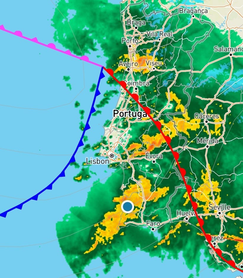
Of course, on the news, storms barrelling into the coast often cause “devastation” and in some cases “utter devastation.”
It might be a trope or journalese, but that doesn’t mean it isn’t true.
The Portuguese government described this as “devastating crisis” caused by the wave of storms – the state of emergency here has been extended and there’s talk of generational flooding...all with a presidential election taking place on Sunday.
Tens of thousands of people were still without power a week after a bomb cyclone and sting jet hit Leiria which is mid-way between Lisbon and Porto quite a way north of us.
Thanks for reading Off-grid and Entertaining in Portugal! Subscribe for free to receive new posts and support my work.
More about those two phenomena later – and about their connection to Britain’s Great October Storm in 1987, Krakatoa, bombing raids to Japan during the Second World War, and the two policemen responsible for sending us British weather.
I have organised my life very carefully around avoiding British weather for the best part of 25 years, so you can imagine my current disappointment, even if I haven’t yet needed to change out of my shorts.
But we’ve been lucky here in the valley – the worst so far was the departure of a large section of protective glass from its moorings next to the pool, which somehow didn’t break in the fall.
A few sections of plastic roof have been relocated and retrieved from the forest, the solar panels deep in the valley have flipped over onto the pillow tank, which have so far avoided puncture despite Daniel’s metal pumphouse roof sprouting wings and taking flight.
One gigantic eucalyptus tree has been uprooted and is being desperately supported by one of its neighbouring trees, slowing its journey to the forest floor...we’re already eying that one up to make a bench.
Check out journalist Jorge Branco’s latest Substack update on the storms:
Many of the tall dead eucalyptus trees on our neighbour’s land that were sheltering in place amid the new growth following the fire a few years ago have taken a tumble making the wood look more like a giant game of Pick Up Sticks.
Our track is a little cut up but has been worse as main roads have been blocked by falling trees and firefighting bombeiroshave been busy with their chainsaws.
At least 13 people have been killed across the country.
And while some communities are still without water, others have far too much.
The incessant conveyor belt of extra-tropical storm systems being guided straight into the Iberian coast since the start of the year has soaked the soil, filled up the reservoirs and sent storm surges flowing up the rivers...to meet the runoff coming down.
The consequences continue to be dramatic.
Riverside shops and homes in Alcácer do Sal were flooded up to the first floor as the Sado River level went up two metres in 20 minutes.
Memories of covering hurricanes, typhoons, cyclones and tornadoes as a foreign correspondent have come rushing back this week.
The chaos in the French Quarter as Katrina hit New Orleans; the entire bowling alley flattened by a twister in Oklahoma (but with the pins in one lane somehow still standing); Manila under water; and then riskily escaping Madagascar’s east coast by helicopter just ahead of a massive storm.
But with the hatches firmly battened down – and lunch plans quite literally rain checked by a downpour that will undoubtedly trap our neighbours on their land until the flash flood has risen and abated – I’ve had time ponder wordplay and meteorology and to have a deep dive into why we’re getting such a hammering this year.
Thanks for reading Off-grid and Entertaining in Portugal! Subscribe for free to receive new posts and support my work.
My geography degree and years of watching weather patterns in our new off-grid home, to understand when to expect trouble, were augmented with a couple of long and slightly confusing conversations with two Portuguese professors.
But I think I’ve worked it out, and with advance apologies to the meteorological purists, I’m going to have a go at explaining it...on the basis that any accuracy lost in the act of simplification is all my own fault.
It’s the Jet Stream.
There we go.
You need more? Ok...
There are a number of jet streams, but the one affecting us is a fast-flowing river of air flowing west to east at around 30,000 feet (9,000m) across the Atlantic.
It’s what planes fly into when going from the US to the UK to save fuel and time...and what they try to avoid on the way back.
It’s created as heat from the equator flows towards the poles and is pulled east by the earth’s rotation. It speeds up where the warm air meets cold polar air.
Like a river it can run fast and straight at 250mph or 400km/h, or meander more slowly making weather systems linger longer…and it can also move further north or further south.
This year it’s further south, broadly bringing icy temperatures to northern Europe, the split of weather we see across North America and more storms to Iberia.
The Baltic’s been, well, Baltic. The minus 34.3C in Lithuania is the lowest since 1996 and Tunisia’s had its heaviest rain in 70 years.
There’s so much more I want to tell you about the Jet Stream...about how it was noticed after the 1883 Krakatoa volcanic eruption created an “equatorial smoke stream”; about how it slowed American bombing raids to Japan in World War Two, but at the same time sped Japanese explosive-laden hydrogen-filled paper balloons towards the US.
(Fo-Go Balloon bombs were the first intercontinental weapons system and there’s a great episode of the wonderful Radiolab podcast all about it).
Some blue-sky, moon shot thinkers believe it could even be a source of sustainable power generation (presumably once they work out how to keep an aerostatic wing at 30,000 feet...and get the electricity back down to earth).
“They [jet streams] meander around the globe, dipping and rising in altitude/latitude, splitting at times and forming eddies, and even disappearing altogether to reappear somewhere else.” [Source: NOAA]
But there’s more to discuss.
The jet stream guides mid-Atlantic storms and affects where the “two policemen” direct traffic to quote Prof Carlos DaCamara from the University of Lisbon.
The conveyor belt of storms are delivered between the clockwise turning Azores High (in the south) and the anticlockwise spinning Icelandic Low in the north...their position and strength also contributes to pushing six named storms into Portugal this year like on a conveyor belt.
Warmer ocean temperatures and a ready source of water vapour arriving on an atmospheric river from the Caribbean...and we here in Portugal have a lot of wind and a lot of rain.
Many British readers will remember the Great October Storm of 1987 which killed 18 people, felled 15m trees with gusts of 115mph...and came the night after BBC weather forecaster Michael Fish joked there wasn’t a hurricane coming.
He was right – in a way – it wasn’t caused by a hurricane, but by the same phenomenon that caused all the damage in Leiria, according to Prof Pedro Miranda, also of the University of Lisbon.
He explained it was years later in 2004 when Prof Keith Browning and colleagues at the University of Reading identified an intense localised wind descending from a great height where you wouldn’t normally expect it in a storm system. They dubbed it a “sting jet” after a noticeable pattern on satellite maps resembled a scorpion’s tail.
They happen in “bomb cyclones” – depressions which form quickly and deepen rapidly to produce higher winds and stormier weather.
The discovery helped forecasters alert people in Scotland in 2011 and 2012 and it was predicted in Portugal last week...only a bit further north than anticipated.
That’s a lot to take it...and if you’ve made it this far, congratulations.
There’s so much more to say, but this is neither the right time or place...I need to head up the hill soon to see what these crazy winds have done.
With the rain still falling and full reservoirs starting to release water into the rivers, there’s more flooding and chaos to come in Portugal no doubt, but a break in the conveyor belt of named storms is predicted.
Somehow, between squalls, our solar panels bring in plenty of power to keep our batteries well and truly topped up.
But it’s time to bring on some more sunshine, a little less wind and a less cloudy dramatic view of our valleys and the mountains beyond. Our tanks and our lakes are full...it’s now time for a break in the weather.
To learn more about how to visit Alastair & Ana’s eco-luxe lodge Valley of the Stars or Vale das Estrelas, visit the website where you can check availability and book your stay. They’re also running their first Wine Retreat in May with the Hutchins Wine Academy. It’s already filling up, but there are still some places available.