In October of 2023, I published a newsletter about scientists using tree rings to date the Seattle Fault. I wrote: “It is a tour de force and beautiful example of science, taking a unique set of features and combining technology with old school-out-in-the-field, mucky, muddy detective work to answer an essential question.” Two members of the group, Pat Pringle and Bryan Black, along with USGS volcanologist Jim Vallance, have done it again. They have solved an essential question via dendrochronology. They have pinpointed the date of the Electron Mudflow to the year 1507.
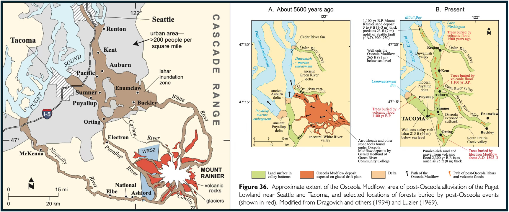
If you are not familiar with this epic mudflow, it’s one of as many as 50 massive debris floods that have rocketed down the slopes of Mt. Rainier. Also known as lahars—a Javanese word for a hot volcanic mudflow, which was introduced into English in 1922—they are some of the most destructive geologic events in our region. Typically started by an eruption (more on that later), a lahar begins with a massive avalanche/rock fall, when magmatic heat melts glacial ice, which mixes with hydrothermally weakened rocks to form a concrete-like slurry. As the mire and muck descends, it can obtain speeds in excess of 125 mph as it scours valleys, climbs ridges and hills, and assimilates whatever lies in its path, ranging from animals to massive boulders to old growth trees. The debris eventually slows down when it hits the lowlands but can still be traveling at 40 mph, dozens of miles from the mountain’s base, and leave behind hundreds of square miles covered in a blanket of death, desolation, and destruction. Dang!
Armed with the knowledge of these potentially deadly natural hazards, emergency preparedness people have been working to aid communities in the path of lahars. For example, several years ago a friend of Marjorie’s bought a house in the small town of Orting on the Puyallup River. On the day they moved in, it was sunny, and they realized they had a wonderful view of Mt. Rainier. The next day, they received a “Welcome to Orting” packet, which contained coupons and other items, including a lahar escape plan. Not a bad idea to have when your town rests atop 20 feet of debris deposited by the Electron Mudflow.
Geologist Dwight Crandall first described the Electron in 1963. He wrote that it consisted of an unsorted mix of rock fragments in a matrix of purplish-gray clayey sand with boulders up to two feet wide. The thickest deposits were 26 feet deep and varied considerably depending upon the original surface topography. Within the deposits, he recovered a wood sample, radiocarbon dated to 530±200 years, not really a precise date. Crandall could find neither source nor a trigger, in particular an eruption.
Thirty years later, geologist Pat Pringle was driving in Orting when he saw a construction site with buried trees. Most, or at least their stumps, still stood upright. He was able to cut sections out of about a half dozen, long dead Douglas firs, bring them into a lab, and age date them. One of them, ELE001 had a good set of rings showing that it died between 1476 and 1522. The dates confirmed Crandall’s time estimates for the Electron Mudflow but Pat wanted a more precise date. He finally got it, in part because of a new focus on tree ring research.
Dendrochronologists such as Bryan Black have benefited in recent years because more raw data has come from low elevation trees. Historically, most tree ring studies focused on high elevation trees because they are better at recording subtle climate change, often the issue that drives research. “Low elevation trees are more complacent, with less variable rings. They just grow no matter what,” says Bryan. That abundant growth has facilitated Bryan’s work on geologic hazards. “The better dating we have allows us not only to figure out the relationships of geologic events but also to exclude potential triggers,” he says.
In addition to the trees Pat found in 1993, Bryan worked with trees collected at nearby Lake Kapowsin, known by some as Stump Lake. One of the coolest things I learned from the report is that Kapowsin is just 519 years old; most lakes in the region date from the end of the last Ice Age, ~13,000 years ago. Kapowsin formed when the Electron Mudflow dammed two small creeks and killed a forest, leaving upright trees later cut by loggers. In 2015, scuba divers pulled up cores from two submerged Douglas fir trees. Pat told me though that based on more than 40 years of sampling submerged trees in the Cascades, western red cedars and whitebark pines are generally “the only tree that last for more than a couple centuries after they die.”
With the additional trees and Pat’s original trees, Bryan did what he had done previously on his and Pat’s study of the Seattle Fault. He compared them with a master chronological dataset of living trees from Vancouver Island that span the years 715 to 1990. The trees told of dying in the summer of 1507. This was a key discovery, Jim Vallance told me.
Now that they knew that the lahar took place in the summer, Jim realized that snow and ice melt could have saturated rocks in the Sunset Amphitheater on the mountain’s summit (previous work had determined that this was the source of the debris) and made a slope failure more likely. Jim also told me that the dating eliminated potential collapse generators such as a heavy, winter snowpack and an atmospheric river event, since those are usually restricted to the late fall or early winter. The new information didn’t clarify what exactly triggered the eruption, but it could help disaster planners; if they know that an eruption is imminent in the summer, the new data helps them be more prepared because they know that rock high on the mountain might be more saturated with water and thus more susceptible to massive collapse, say Jim.
Tying into the cultural history of place and people who have lived here for thousands of years, the paper mentions two Indigenous stories that reference the Electron. “The young man’s ascent of Mount Rainier” (from Arthur Ballard’s Mythology of southern Puget Sound) and “The lake on Mount Rainier” (from Ella E. Clark’s Indian Legends of the Pacific Northwest) describe flood water and debris that buried the Puyallup River valley near the present town of Orting. As one member of the Puyallup Tribe told me, he has longed used these stories as a way to illustrate the enduring legacy of oral histories and how they often provide details later teased out by more recent science.
One aspect of the legacy of lahars is that they devastate whatever and wherever they encounter: loss of life, loss of habitat, destruction of communities, destruction of travel routes. They are not to be trifled with; the great Electron Mudflow will not be the last to cause problems and the more we know through good scientific research, the better. The tree ring work is not only totally cool, but also a key way to further the relationships between people and place, and hopefully, help create more resiliency for future catastrophic events.
February 12, 2026 - 6:00 PM - Last week I mentioned that I will be chatting with my good pal Emily White about my upcoming book on the Cascades. It’ll be a sort of behind-the-scenes look at how the book came to be from ideas through research to editing and design. Emily has been involved with the book since the beginning so I think the conversation should be fun and informative. Plus, it’s free. Here’s a link to register.
Thanks to Bryan Black, Pat Pringle, and Jim Vallance for help with this newsletter.