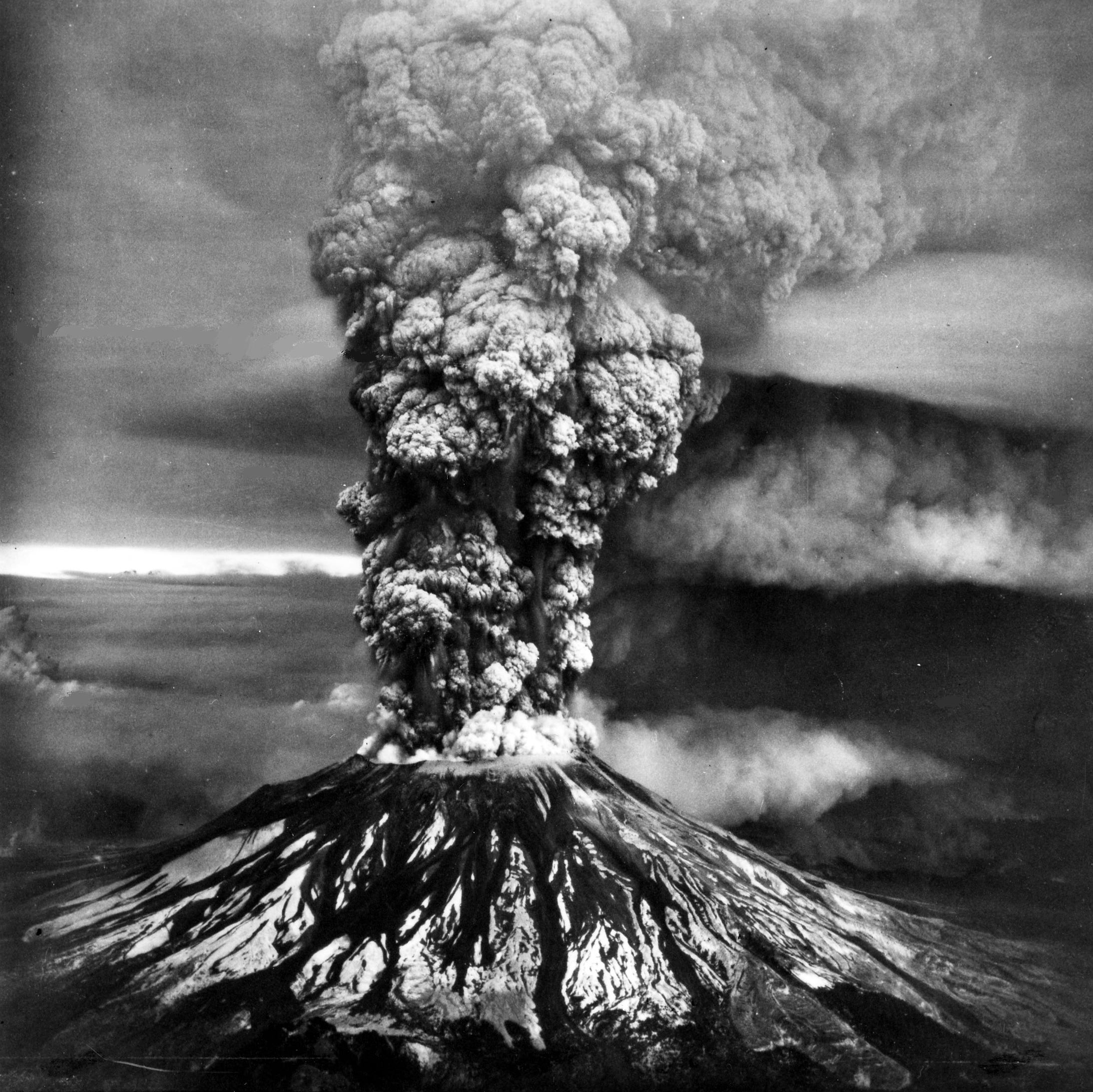
As has happened every year since 1981, we in the PNW noted the anniversary this week of the eruption of Mount St. Helens. At 8:32 AM on May 18, 1980, the mountain erupted for the first time since the 1850s. We couldn’t see the eruption from our house in Seattle but I have a vivid memory of watching the coverage on our black and white television. I was in awe of the seething mushroom cloud of ash and debris, the scary-looking tree-choked rivers, and the cloud of blackness that shrouded nearby towns and cities. (If I remember correctly, my brother was driving home from college and didn’t have a clue what was going on…alas.)
Of the state’s five volcanoes, Mount St. Helens is the most active and youngest, at least its pre-1980, 9,677-foot summit. During its first stage of life, a sort of proto-volcano—a low hill, perhaps 2,000 to 3,000 feet tall though it may have been higher at times—existed from about 270,000 to 35,000 years ago. Between 35,000 and 4,000 years ago, the little edifice started to bulk up, reaching to about 6,000 feet, though still more lumpy than conical. I find it completely fascinating that people would have seen this growth; the oldest archaeological site in the vicinity shows habitation back to 9,200 years ago. In Sahaptin, the language of the Cowlitz Indian Tribe and the Confederated Tribes and Bands of the Yakama Nation, the name Lawetlat’la means smoker, a clear reference to the volcanism.
Mount St. Helens then entered its mature, modern stage, ultimately forming the beautiful pre-1980 summit though not until the addition of rock in an eruptive cycle from about 1650 to 1725. Another round of eruptions occurred in the middle 1800s. They were witnessed by many who recorded the events. On March 30, 1847, artist Paul Kane wrote of having “a fine view of Mount St. Helen’s throwing up a long column of dark smoke into the clear blue sky.” When George McClellan passed by on July 31, 1853, he noted seeing smoke rising from Mount St. Helens. Four years later, an unnamed reporter for the Washington Republican wrote of the mountain “presenting a grand and sublime spectacle.” After this cycle, Mount St. Helens went quiet until 1980.
Following the big blast of May 18, five additional eruptions in 1980, all much less grand, generated ash plumes, pyroclastic flows, and dome destruction. In addition, another twenty dome building eruptions between December 1980 and October 1986 produced a nearly 900-foot-high lava dome. The mountain then shut down until September 25, 2004, when seismicity picked up to levels not recorded since 1986.
Coincidentally, I was on the summit with friends on September 24 and was supposed to meet a group of University of Washington geologists to go into the crater on the 25th. They never showed so we hiked out onto the Pumice Plain. We knew nothing of what was happening at Mount St. Helens until we arrived back in Seattle on the 26th and my mom told me that land managers had closed access to most of the mountain. Seven days after we were on the summit, Mount St. Helens erupted with a small plume that rose about a mile over the summit. It remained active until 2008 and has not erupted since.
The other night I had the privilege of hearing Carolyn Driedger of the United States Geological Survey give a talk for the Mount Saint Helens Institute. I have long known Carolyn; she’s a great communicator about the mountain. She made several key points particularly in regard to science. Mount St. Helens is the “master teacher,” which provided lessons to scientists and emergency managers around the globe that helped save uncountable numbers of people. The mountain also showed how research couldn’t be siloed; scientists needed to cross disciplines and share information in order to understand such a complex situation.
This may seem rather obvious but Carolyn told of how the different researchers at the time didn’t collaborate. The results could be catastrophic with a failure to communicate information needed to help in predicting future eruptions. She noted that when the USGS built its Cascades Volcano Observatory in Vancouver, WA, it purposely designed the facility so that researchers in different fields would have adjacent offices with the hope of cross discipline discussions. This plan has been a success.
As I have written previously, Mount St. Helens is one of my favorite locations in Washington. It is both a geological and an ecological treasure unlike any other spot in the state, and I would argue, in the world. Not only is it beautiful and inspiring, but it also has, as Carolyn noted, provided essential scientific information that has rewritten our understanding of volcanoes, emergency response management, and how to communicate in a disaster. The mountain has further rewritten our understanding of succession, or how plants and animals replace another species over time following disturbance, such as a volcano or flood. In the words of ecologist Jerry Franklin, one of the region’s key forest researchers: “The learning that initiated at Mount St. Helens is global. In a sense it’s universal.”
And yet, I don’t think the mountain gets the recognition it deserves. I am always surprised by the number of people I talk to who haven’t been to the volcano. They think nothing of driving three hours north to hike in the North Cascades but don’t do the same going south. I understand that access has been difficult the past few years, and that a lack of funding has resulted in the closure of visitor services, but for anyone who does take the time to discover the stunning geology and ecology, you will be richly rewarded.
Another problem is that Mount St. Helens isn’t as sexy as it used to be. The first few decades of research led to the unprecedented discoveries that shifted the paradigms of geology and ecology, but those stories are still playing out. Forty-six years is a mere blip in the geological and ecological timelines of a landscape like Mount St. Helens. New research continues to help clarify, recalibrate, and unearth both the simple and complex relationships that are shaping the future landscape, as well as forcing scientists to ask new questions to help further the lessons that this master teacher is providing.
If you want to know more about Mount St. Helens, I recommend the following.
Eruption by Steve Olson tells the story of the 57 people who died on May 18, 1980, and how they came to be where they were. Not surprising, it was a mixture of politics, history, and geology.
After the Blast by Eric Wagner provides the best account of the amazing ecological stories of the mountain.
The 1980 Eruptions of Mount St. Helens, USGS Professional Paper 1250 - Weighing eight pounds and totaling 844 pages, 62 scientific studies, and a map, the Twelve-Fifty is a stunning account from the mountain’s reawakening on March 20, 1980 through the May 18 eruption to the months of research that followed. It is not a document to be taken lightly.
Roadside Geology of Mount St. Helens by Pat Pringle - An approachable and practical guide to the mountain’s geology.
I also recommend the classes and programs at Mount Saint Helens Institute.