Hey friends, welcome back. We’ve got a lot to cover and a big storm incoming. Let’s jump into it.
A Wild Weekend Setup Across the U.S.
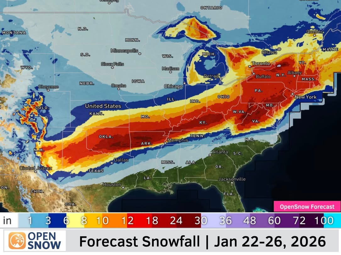
According to OpenSnow, this weekend into early next week is shaping up to be a wild one across much of the country as Arctic air collides with deep moisture and a strengthening subtropical jet stream.
This is not a subtle pattern.
We’re talking about a large, high impact system that starts in the Southern Rockies, then moves east, spreading significant winter weather across the Central and Eastern U.S.
The Southern Rockies Finally Get Some Love
Let’s start with the feel good story.
The Southern Rockies are finally going to get meaningful snow.
After a choppy, frustrating start to winter for parts of southern Colorado and northern New Mexico, this storm develops right over that region. OpenSnow guidance shows these areas positioned for some of the bigger totals in this system.
This is the kind of storm that:
* Refreshes terrain
* Changes the feel of the mountain overnight
For skiers and riders in the Southern Rockies, this is exactly what winter ordered. It won’t be a season-changing storm, but we’ll take anything and everything at this point.
The Storm Heads East
As the system moves east, it expands and strengthens.
According to OpenSnow:
* Moderate to heavy snow extends north into Pennsylvania, New York, and New England
* Snow impacts areas north of the Maryland Pennsylvania border and west of I-95
* Parts of the Mid Atlantic are flirting with up to two feet of snow
* New England generally looks to be in the 6 to 18 inch range
That’s real snow in the East. The kind that changes weekend plans and sets up great conditions for resorts.
Meanwhile, warmer air will push into the Southeast and parts of North Carolina and the southern Mid Atlantic. That means some areas see snow first, then a transition to sleet, freezing rain, or rain.
In short, it’s going to be a wild, wintry scene for almost everyone except Florida.
This Russian Region Is Buried
If you don’t like shoveling your driveway, be thankful you’re not dealing with the snow totals coming out of this area in Russia.
One of the wildest winter weather stories on the planet right now isn’t happening at a ski resort. It’s happening in Kamchatka, Russia.
Kamchatka has been hit with its heaviest snowfall in roughly 60 years.
In January alone, some areas have seen more than two meters of snow, over six feet, on top of 3.7 meters in December, which is more than twelve feet.
Streets, neighborhoods, and cars are completely buried. Snowbanks tower above buildings. People are digging tunnels just to get outside. Videos show residents casually walking across what looks like rolling snowfields where roads should be.
Scientists say this extreme snowfall is tied to a very wavy jet stream and a weaker Arctic polar vortex, allowing deep cold air to plunge south while moisture stays locked in place.